Koguva sadam
Saaremaa and Muhu · Väinameri
At a glance
- 1.2 mPermitted draughtpilot book
- 52.5 mMaximum lengthregister
- 5 mMaximum beamregister
- 1.6 mQuay depthregister
- 15 April – 15 DecemberNavigation periodregister
Permitted draught is the limit the sailing directions publish for entering; quay depth is the register's figure for the deepest quay — other quays may be shallower. Neither guarantees a berth that suits your boat.
- 3 knkiirus ei tohi ületada 3 sõlmeoriginal Estonian, not translated
- 12 m/stuule kiirusel üle 12 m/s ja laine kõrgusel üle 1 moriginal Estonian, not translated
Services
- Shore powerUnknown
- WCUnknown
- CaféUnknown
- SlipwayUnknown
- ParkingUnknown
Prices and availability
Price not published — ask the harbour. Confirm prices and availability for your dates with the harbour, including which services the price covers.
Arrange your place, price and arrival directly with the harbour.
Arrival
Saare maakond, Muhu vald, Koguva küla, Koguva sadam, 94724
Harbour surroundings
Not for navigation. See every harbour on the map.
View in Nutimeri (Transpordiamet, opens in a new tab) — Transpordiamet
Official navigation charts and markers, for information only — not a primary navigation aid.
Sailing directions
Based on a published sailing directions guideSisse- ja väljasõidul on eesõigus väljasõitvatel laevadel. Speed limit: kiirus ei tohi ületada 3 sõlme. Entry and departure ban: tuule kiirusel üle 12 m/s ja laine kõrgusel üle 1 m.[2]
Use together with an up-to-date nautical chart and navigational warnings.
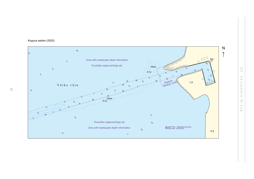
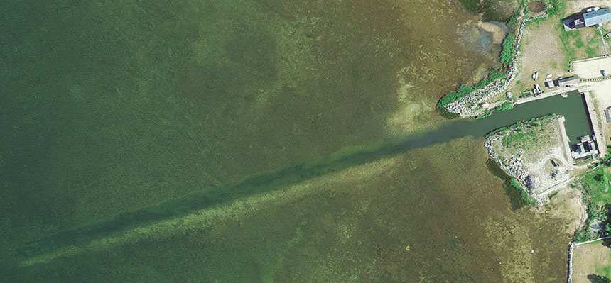
Depths and dimensional restrictions
The maximum permitted draught is 1.2 m. Published depths alongside are quay 1: 1.6 m, quay 2: 1.6 m, quay 3: 1.6 m and quay 4: 1.6 m. Depths are referenced to EH2000.[2]
Depths quay by quay (4)
| quay 1, 2, 3 and 4 | 1.6 m |
|---|
Sources
- Sailing directions Lootsiraamat 2.3 — Väinamere W osa
- Sailing directions Lootsiraamat 2.3 — Väinamere W osa
Published 12 Sept 2026 · revision 4
Historical wind statistics
Prevailing winds
How often the wind blew FROM each direction, May–September 2021–2025.
Modelled data, not measured at the harbour
Rings: May (inside) → Sep (outside). Figure at the edge: share of the whole season.
The wind most often came from SW (12 % of the season's hours).
- under 3 %
- 3–6 %
- 6–9 %
- 9–13 %
- 13–20 %
- 20 % or more
Regional model data cannot show how sheltered the harbour is, or how the wind moves around its piers and breakwaters.
Data as a table
| Wind from | May | Jun | Jul | Aug | Sep | Season |
|---|---|---|---|---|---|---|
| N | 4.7 % | 4.0 % | 3.5 % | 3.8 % | 5.9 % | 4.4 % |
| NNE | 5.4 % | 3.9 % | 2.9 % | 2.7 % | 4.6 % | 3.9 % |
| NE | 5.0 % | 2.4 % | 4.1 % | 3.3 % | 2.2 % | 3.4 % |
| ENE | 3.6 % | 2.3 % | 4.8 % | 3.7 % | 3.1 % | 3.5 % |
| E | 4.1 % | 3.7 % | 4.0 % | 3.0 % | 4.2 % | 3.8 % |
| ESE | 3.9 % | 3.7 % | 3.8 % | 3.5 % | 6.7 % | 4.3 % |
| SE | 4.1 % | 3.6 % | 3.7 % | 5.6 % | 8.5 % | 5.1 % |
| SSE | 7.2 % | 7.4 % | 5.5 % | 7.6 % | 9.0 % | 7.3 % |
| S | 7.0 % | 7.1 % | 5.0 % | 8.2 % | 7.8 % | 7.0 % |
| SSW | 9.3 % | 6.3 % | 6.7 % | 8.7 % | 7.2 % | 7.7 % |
| SW | 8.5 % | 13 % | 17 % | 13 % | 10.0 % | 12 % |
| WSW | 8.7 % | 12 % | 14 % | 11 % | 7.9 % | 11 % |
| W | 6.1 % | 7.9 % | 8.0 % | 7.6 % | 6.5 % | 7.2 % |
| WNW | 6.6 % | 6.9 % | 6.0 % | 7.9 % | 4.5 % | 6.4 % |
| NW | 8.7 % | 8.9 % | 5.2 % | 5.6 % | 5.1 % | 6.7 % |
| NNW | 6.6 % | 5.9 % | 5.7 % | 4.5 % | 6.8 % | 5.9 % |
| calm | 0.4 % | 0.7 % | 0.4 % | 0.3 % | 0.2 % | 0.4 % |
| % | 100 % | 100 % | 100 % | 100 % | 100 % | 100 % |
Calm: below 0.5 m/s; counted in the total, not in any direction. 18360 valid hours of 18360 expected.
Source: ERA5 reanalysis (ECMWF / Copernicus Climate Change Service), ~25 km grid · model grid point 11.5 km south of the harbour (58.500, 23.000) · May–September 2021–2025, UTC · 18360 valid hours of 18360 expected · Data retrieved 2026-10-07 · Contains modified Copernicus Climate Change Service information (ERA5), CC BY 4.0
Data: port register, record updated 19 May 2025.
View from the ground
Visitor observations
Sailors' experiences, not the harbour's official information.
Practical details and harbour documents
- Address
- Saare maakond, Muhu vald, Koguva küla, Koguva sadam, 94724
- Navigation period
- 15. aprill - 15. detsember
- Harbour master
- Ragnar Põllu
- Position
- 58.59601° N, 23.07399° E
- Phone
- +372 5133446
- info@koguva.ee
All services in the register
Veesõiduki sildumise võimaldamine · WC · Parkla · Slipp · Elekter · Kohvik/Restoran
Nearest harbours
Straight-line distance. Nearest does not mean suitable for your boat.
Saaremaa, Muhu, Abruka and Vilsandi. Depths in the Väinameri are modest — draft is the binding constraint here. All harbours in Saaremaa and Muhu →
Help complete this harbour
These facts are still missing. If you know one, tell us — every suggestion is reviewed before it is published.
No berth count yet — it tells a visitor whether they are likely to fit.
In Mervare Crew? Use your account email in the suggestion and the verified contribution counts for you. Mervare Crew →
Suggest a video for this harbour
Add a 3–30 second video file or a YouTube link. Videos are reviewed before publication; a suitable short clip may become the page hero.